Disaster Planning

US Coast Guard during hurricane Katrina rescues. Photo courtesy of the US Coast Guard
Federal
State
- Alabama – State of Alabama Emergency Management
- Florida – Florida Division of Emergency Management
- Louisiana – State of Louisiana Governor’s Office of Homeland Security & Emergency Preparedness
- Mississippi – Mississippi Emergency Management Agency
- Texas – Texas Department of Public Safety Division of Emergency Management
Other
- American Planning Association’s Hazards Planning Center
- Association of State Floodplain Managers (ASFPM)
- Coastal Hazards Center of Excellence
- Hazard Reduction & Recovery Center at Texas A&M University
- International Code Council (ICC)
- Insurance Institute for Business & Home Safety (IBHS)
- National Centers for Environmental Information (NCEI)
- NOAA Climate.gov
Vulnerability and Wetland Loss
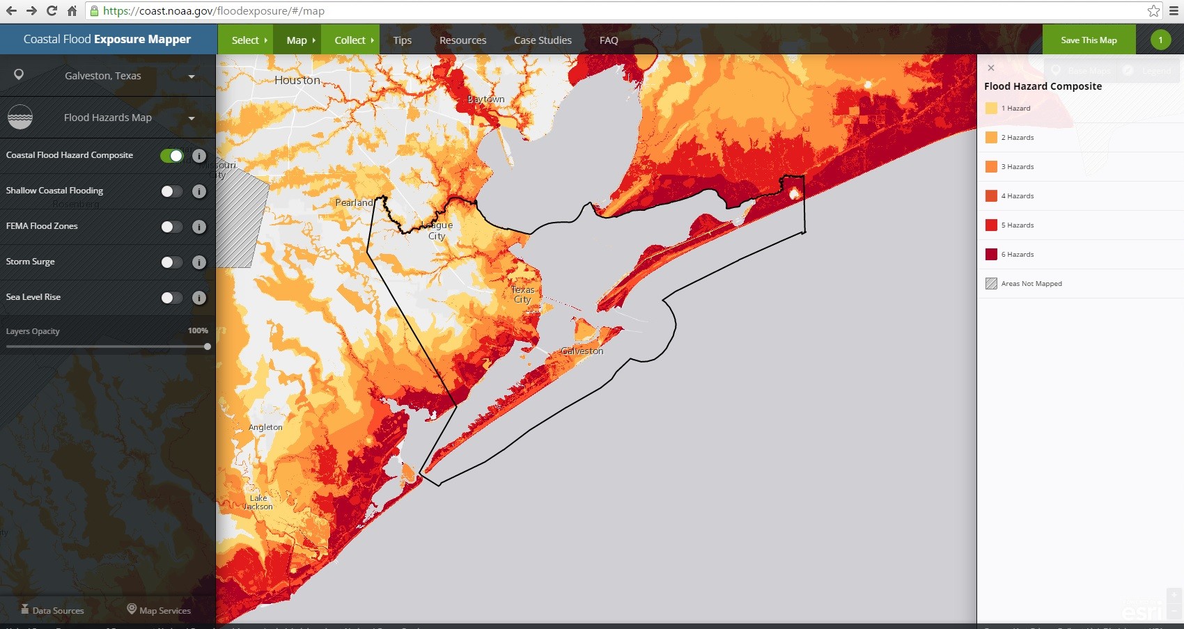
Coastal Flood Exposure Map, NOAA This screenshot shows composite coastal flood hazards in Galveston County, Texas. Societal, infrastructure, and ecosystem risks can be overlaid to assess vulnerability.
- Coastal Resilience Mapping Portal – http://maps.coastalresilience.org/network/
- Coastal Flood Exposure Map – https://coast.noaa.gov/floodexposure/#/splash
- C-CAP Land Cover Change Atlas – https://coast.noaa.gov/ccapatlas/
- Hazards U.S. Multi-Hazard (HAZUS-MH) – https://www.fema.gov/hazus
- Getting to Resilience: A Community Planning Evaluation Tool – http://www.prepareyourcommunitynj.org/
- Sea Level Rise Viewer – https://coast.noaa.gov/slr/
- U.S. Climate Resilience Toolkit – http://toolkit.climate.gov/
- National Flood Hazard Layer – http://fema.maps.arcgis.com/home/webmap/viewer.html?webmap=cbe088e7c8704464aa0fc34eb99e7f30
- Coastal Flood Loss Atlas – http://fema.maps.arcgis.com/home/webmap/viewer.html?webmap=b4ae0b42789447b18c4b919682b848ad
- National Sea Grant Resilience Toolkit – http://seagrant.noaa.gov/WhatWeDo/ResilienceToolkit.aspx
- US Census Bureau’s American FactFinder – http://factfinder.census.gov/faces/nav/jsf/pages/index.xhtml
- EPA’s Adaptation Tools for Public Officials – http://www3.epa.gov/climatechange/adaptation/tools.html
- USFWS’s Coastal Barrier Resources System(CoBRA) Mapping Application – http://www.fws.gov/cbra/Maps/Mapper.html
- NOAA’s Essential Fish Habitat Mapper v3.0 – http://www.habitat.noaa.gov/protection/efh/habitatmapper.html
- NOAA’s Natonal Marine Protected Areas Center GIS Clearinghouse – http://marineprotectedareas.noaa.gov/sciencestewardship/gis/
- Climate Central’s Surging Seas: Risk Zone Map – http://sealevel.climatecentral.org/maps/risk-zone